Monday, October 25, 2010

The Circle of Life...

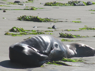
First of all, the photos in this entry are not mine. They are taken by a friend when she was at the Oregon Coast some time ago. I normally don't post others' photographs, but these are particularly poignant and struck a chord with me, for a number of reasons that will become apparent. I also thought they are very good photographs. She gave me permission to show her photos, as well as sharing her thoughts that were included in an email to me.


"Unfortunately this seal is dying from sort of disease. It was posted to not touch sea lions or seals dying on the beach... I so... so wanted to put its head in my lap and tell it I was sorry he was dying ... I didn't know what to do... but I felt it so deep and it was dying without reason... I felt so helpless... but I guess in life ... in my own life I feel this too.. " (Joan)

The word "poignant" means evoking a keen sense of sadness or regret. I think it is a particularly appropriate word, especially the "keenly felt" part when one witnesses the dying of another creature, as is the case here. Yet it is nature, with all of her harshness set in the midst of the beauty around...and also inescapable. Our bearing witness to it inevitably causes us to consider the world around us, and our place in it.

You see...what is especially poignant is that my friend Joan has cancer. I don't know her prognosis. Her particular type is rare and not much is known about it. However, what is striking to me is her attitude...wanting to comfort the seal in his final moments...to reassure him that he has meaning.

Meaning.

Perhaps that is what she is seeking? Isn't that what we all keenly desire?

Rain or Shine

A friend was recently surprised to hear that our local farmers market (The Montavilla Farmers Market) was still open, in windy and rainy October.

"What is left to harvest?" he said, and I have to admit I was surprised at what is still available. Notice that I use the present tense..."is". Now, I have to admit that the weather is markedly different in October than it was in August, for my last blog entry about the market banquet, as the following photos will attest. What you will also find, however, is that there is still much bounty to be found at the market.

During one of the many downpours one can experience an urban market phenomenon - the tent waterfall. It seems that the rain collects in the low points of the canopies, only to be coaxed over the edge into a cascade of water during a sudden gust of wind...and sometimes down the back of one's jacket. Not pleasant!

Fruit is still plentiful, such as this wide array of apples.

Fennel and lettuce...


...and baskets of vegetables, to numerous to name.

The photos above bear testimony to how much is still available...and as much as I love Brussels Sprouts, I never knew how tall those stalks can get.

Isn't it funny how kids are naturally attracted to water...and mud puddles?

Gretchen Jackson, the Market's manager takes a break to eat from Thai Mama's delicious offerings...one of the few remaining eateries at the market. Yes, sadly the lemonade stand is gone, though remarkably the ice cream lady was still there! The caramel apples were amazing. Kitchen Dances and the Wild Wild West Barbecue are also still open.

Even the musicians held fast against the rain and wind, serenading the shoppers with song and twang. (I may be wrong, but I heard the guy on the right is backup guitarist for ZZ Top.)

Oh...and the day was not without a casualty. A gust of wind blew down a tent and buckled one of the legs. So the score at the end of the day was Weather: 1, Market: 0, though the real winners are those of us in the community who can still find fresh local produce, and the opportunity to hang with some pretty cool people.
Better hurry, though! Only open one more day in October, and then only open on the Sunday before Thanksgiving...and that's it for the season. (Stay tuned for the abbreviated version later)

Sunday, October 10, 2010

Off the Beaten Path - Part 1

Every so often we like to explore, and perhaps take a turn off the highway and see where a road takes us. Sometimes it's by myself, in conjunction with a business trip somewhere in the Pacific Northwest...or anywhere for that matter. This time Beth and Frankie came with me when wanderlust struck, and we drove east on Interstate 84 towards The Dalles, then south on Highway 197 (or the "The Dalles California Highway" as it used to be called). The photo above is that highway as it climbs out of the Columbia River Gorge and into the central Oregon plateau, winding through wheatfields and orchards.


Along Highway 197 are numerous reminders of the past, such as this old overgrown cemetery. Many of the gravestones date before the 20th century...reminders of those who joined the Great Migration of the late 1800's and settled in this area. Mount Hood can be seen in the distance.

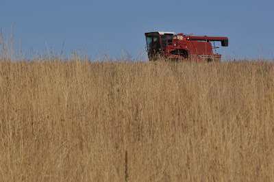
Wheatfields are not complete without the equipment necessary to harvest the grain, such as this combine parked in the middel of a field.
About a half hour south of The Dalles is a little community called Tygh Valley, where we turned eastward on Highway 216, or the Shearer's Bridge Road. I believe the name "Shearer's" came from the sheep that this area was noted for, in the latter part of the 19th and early part of the 20th century.


Shearer's Falls is one of the larger waterfalls on the Deschutes River, which eventually feeds into the Columbia and thus is part of the salmon's migratory path. It is also one of the last places where Native Americans can still dip their nets in the same manner as they have done for centuries. I sat here for hours, waiting to capture a salmon jumping into the falls...but alas I had the same luck capturing one on camera as I had with a rod and reel.

After Shearer's Falls we crossed the Deschutes River and continued east. The view is typical...sagebrush, weathered fenceposts, winding roads and high voltage transmission lines. Thousands of megawatts of power travel through these lines from the dams on the Columbia to the homes and businesses of Southern California.

Highway 216 then turned into a secondary road, which after a few apprehensive miles finally intercepted Highway 97, which happens to be a major north-south trucking route between Canada and Mexico. Along the way are small towns, some of which are abandoned like this gas station.

The pump above showed a price of 66 1/2 cents a gallon, so it has probably been some time since any fuel actually flowed through the hose. The station is in the town of Kent.


A little further south is the town of Shaniko, which was founded in the late 1800's as a center for wool harvest, production and shipping. Up to a few years ago it wasn't much more than a ghost town until the hotel (built in 1900) was restored and reopened. Unfortunately the hotel is now closed and for sale signs were seen in the windows. Above is the boardwalk on two sides of the hotel.


Buildings aren't the only old thing one finds at Shaniko. There were several old cars slowly rusting away while grass grows around and into them.


A small barn held several old horse-drawn wagons, though the dry environment has taken a toll on the wooden construction.


Shaniko barn and fire truck.

The old Shaniko Hotel, a grand lady of the region that still looks good despite her age. I'm sure the walls have some wonderful and interesting stories.


Daylight left us shortly after this stop, and we made our way back to Portland, via a delicious dinner at the Hood River Hotel...and regrettably had left my camera in the car at that point.